YOU ARE HERE: Home > Government > NASA
|
|
NASA Edge | SMAP Launches from Vandenberg
|
|
|
NASA Edge | SMAP Launches from Vandenberg
|
 |
Join the NASA Edge crew as they cover the launch of the Soil Moisture Active Passive (SMAP) spacecraft live from Vandenberg Air Force Base. Special guests include NASA Administrator Charlie Bolden, SMAP Project System Engineer Shawn Goodman and Lt Col Brande Walton and Joseph Sims from the Air Force. No word on the Co-Host’s whereabouts.
TRANSCRIPT
Featuring:
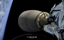
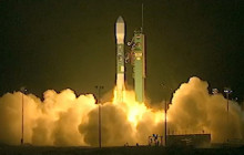
CHRIS: We’re back with NASA’s Administrator, Charlie Bolden, and NASA EDGE cohost. Now Charlie, we have an important launch today with the SMAP satellite. CHARLIE: Critical lunch. CHRIS: And it’s all part of looking at the global climate change. How important is the SMAP Mission? CHARLIE: This mission is very critical. It’s the fifth and final of my, what we call the Year of Earth. So in 11 months we will have launched five Earth science missions, which is sort of unprecedented. And this one, for a couple of reasons, really finishes out the suite because this allows us to look at global moisture in the soils. It also allows us to differentiate from space, between frozen tundra and just regular old turf. Which my scientists tell me, I not going to pretend to understand it all, but they tell me that’s very important to understanding the CO2 cycle. We believe that’s one of the big contributors to climate change, so the more that we understand how about it the better. The other thing that SMAP allows us to do, and I do like this stuff because as a pilot flying radar every once a while, you always want to be able see small chunks. CHRIS: Right. CHARLIE: So up until now, up until SMAP, we saw big chunks of Earth, like 25-mile resolution. SMAP is going to drop that to a quarter. So we’re going to actually be able to see pieces of earth in terms of a 6-mile sector. It also is going to look more frequently. You want to be able to look as often as you can if you’re trying to understand climate, make weather forecasts and the like. And you want to be able to see as small a chunk of Earth as you can. So SMAP gives us both of those in this one mission. So it is critical. CHRIS: From a technology standpoint, it’s amazing how we’re going to be able to actually look at 5 cm in the soil and determine the moisture content. It’s amazing. CHARLIE: Well, the other thing is the fact that you can now discern between freeze and thaw. You can look from space and determine whether you’re looking at frozen ground that’s causing CO2 to go back out into the atmosphere or whether you’re using it because the vegetation and everything else that is using it in photosynthesis and other things. CHRIS: Now SMAP is not the only satellite that’s going up on the Delta 2. We have some CubeSats on board. CHARLIE: As a matter of fact, I don’t think I will get in trouble if I do this, but go ahead and ask your question while I try to get my tool. CHRIS: Your getting your tool out. Well, there you go. CHARLIE: They didn’t ask me to do this but I will do this. This is for the… CHRIS: The ELaNa X mission. CHARLIE: Can everyone see it? This is for all of you who are the CubeSat guys, who are right next-door here as a matter-of-fact. I accused them all of being from high school. They were not. They are in College. Some of them are in grad school and others are adults but they all look like kids. But they’re flying these things that are not much. When you sit it down on the coffee table it’s actually about the size of that. So, that is the footprint of a CubeSat. And we are enabling high school students, college students and everybody to learn how to send things to space. And they’re putting them in small packages that are relatively inexpensive and learning lots about Earth. CHRIS: Now when we look at SMAP, the Soil Moisture Active Passive, what is the importance of that satellite? SHAWN: Well, scientifically it’s important because it closes the gap that we have in our models about climate change. We’re not really sure whether as climate changes we’ll see more or less soil moisture and you can imagine water in the soil is critical for plant growth or human life or the growth of produce and livestock. So launching the SMAP mission gives us this ability to make these global measurements, the first, ever global measurements that enhance our ability to predict both weather and climate. It’s critical to all of us. CHRIS: Now when you look at the name, Soil Moisture Active Passive, what does it mean by active passive? SHAWN: Well, there’s a single instrument reflector; that large antenna that you see. We have a radar & radiometer that use that reflector to combine the RF energy and get it into the spacecraft and back from the ground. Half of the instrument is a passive measurement. It measures energy from the ground. We call it brightness temperature. The brightness temperature is a measure of how much moisture is in the soil. The active part is in effect sending radio waves to the reflector and then bouncing them off of the earth and back again. Some are just listening and some are sending and listening. That is why it is called active and passive. CHRIS: From my understanding, you’re actually going to be looking at the soil moisture content in the top 5 cm layer of the Earth? SHAWN: That is correct. The particular orbit that we have allows us to measure the soil moisture across the planet every three days. Every three days, we get a picture of the totality of soil moisture for the entire planet and every eight days it repeats exactly. This will be the first time we will get global measurements of the soil moisture or water content of our soil across the world ever in human existence. The resolution provided by the radiometer at the 10 km resolution for soil moisture and the 3 km soil moisture resolution allows us to look at the freeze-thaw state. We can see when the vegetation-growing season might change and therefore how much carbon gets taken up by the atmosphere. That’s a critical element in understanding how much carbon we pull out of the atmosphere when we start to think about greenhouse gases and things like that. CHRIS: This provides a gap, I guess you could say, in the models in terms of predicting climate change. SHAWN: Yes. Again, we’re not sure as a function of climate change whether or not we wind up with more moisture in the soil or less; whether or not we see more droughts or floods and where those might occur. Soil moisture is a critical element in understanding how those weather pattern changes and how much soil moisture there is. I imagine it is very similar to perspiration. The water at the surface of the Earth is a cooling agent in some ways and evaporates into the atmosphere for rain and allows the planet’s temperature to change. When you understand that missing component, you start to understand better how the weather and climate are going to change on the planet. CHRIS: Looking from an engineering side, what were some of the challenges of designing that satellite? It looks like the top half rotates one way and the bottom half rotates the other way. Can you explain that? SHAWN: Originally, we were on a much smaller rocket. Launch vehicle is what we call it. Packaging that large reflector that you see; it’s a 6-meter reflector. It is about 20 feet in diameter. Squeezing that whole thing down much like origami into a package that could fit into the rocket and open up to that large size you see on orbit was a challenge. In addition to that large rotating reflector is inertially significant. It wants to spin that little spacecraft that is about the size of a refrigerator below it. That was a technical challenge. How do you spin this large thing with this little thing and keep the whole thing from wobbling. CHRIS: How difficult was that? You’re getting that data. That data is coming back up; it’s hitting the sensor and getting funneled down through the funnel. SHAWN: That’s correct. I imagine it is very similar to; I don’t know how best to describe it; standing in the middle of one of those kid playground things you spin. You’re holding a magnifying glass trying to look at an ant on the ground. You’re shaking around and at the same time trying to look at the ant. The SMAP spacecraft has to maintain its attitude while spinning this very large reflector above it to make these soil moisture measurements. CHRIS: Project System Engineer, not Systems Engineer, explain your roll in the mission. SHAWN: I’m the technical integration function for the mission. We have a Mission System that defines how we communicate with the spacecraft; how we command it; how we get signals down by the antennas; the large antennas you see. We have an instrument system that’s developed the reflector; the radar and radiometer that make the active and passive measurements. We have the spacecraft, which is effectively the vehicle that carries that instrument around. My responsibility is to make sure the interfaces or requirements across all of those elements play out correctly so the systems work together. Ultimately we test it and we’ve got the right design, vision, and architect to do the mission we need to do for the science. CHRIS: You’re the go between the scientists and engineers. SHAWN: Sort of. I guess I am. I’m sort of the broker. I’m the negotiating agent across those elements. CHRIS: You’ve got to make everybody happy in your job. Don’t you? SHAWN: I don’t have to make them all happy but they all have to work together. CHRIS: Make sure you have mission success. SHAWN: Exactly. CHRIS: Shawn, I want to thank you so much for coming out here on this 2nd attempt. SHAWN: Thank you. It’s just a pleasure being here. I’m glad you had me back again. CHRIS: Hopefully we’ll get the Delta 2 up and SMAP ready to go. SHAWN: I believe we will. CHRIS: I had a chance to talk with Lieutenant Colonel Brande Walton of the United States Air Force earlier this week. We’re going to look at what the Air Force’s roll is in the launch of the Delta 2. CHRIS: Colonel Walton, what’s your roll at the 30th Space Wing at Vandenberg Air Force Base? LT. COL. WALTON: As the commander of the 2nd Range Operations Squadron, primary mission is command and control of the Western Range. That includes mission assurance but mostly public safety. We want to make sure air, land and sea is safe for launch and after launch. CHRIS: When you talk about public safety, what are some examples of public safety for a typical launch here at Vandenberg? LT. COL. WALTON: There are many facets of public safety. We have to, again, make sure all facets are good and go for launch. For land, we have to make sure that within the area in which it’s launching there are not people in that area. For example, we make sure we have AmTrak trains that go through. We will actually hold the train prior to launch to make sure we’re keeping the public safe. For air, we make sure no aircraft are flying through the corridors. For sea, we make sure that there are no boats in the specific protected areas. We don’t want anybody just watching the launch. You could have a danger there. We make sure our instrumentation is go. For that, can it track the vehicle because we have to make sure we can track the vehicle and always know where the vehicle is at minus count in case it’s performing erratically. CHRIS: If you have a situation where you had a boat or a surfer out in the water or someone driving through not knowing what’s going on, that could be grounds for delaying the launch? LT. COL. WALTON: It could. There are a lot of rules with it. One surfer, probably not going to delay the launch but if there is a boat going through then we will take information. Our LDA, Launch Decision Authority, with Safety will then make the ruling on if they’re a go or no go. There are a lot of rules that go with it. CHRIS: In this particular case when NASA comes to Vandenberg Air Force Base to launch a satellite along with the CubeSats into space. I guess it’s more of a logistic challenge because now you have a partnership between NASA, the Air Force, and, in this case, the ULA, which is in charge of the launch vehicle. How is it challenging for all of those entities to work together as a team? LT. COL. WALTON: It’s not challenging. We do that for every mission but we do have to make sure we are locked step with each partner, with NASA, with ULA, and again with the Air Force team. For example, today we had a crew academic session with the range and we invited both NASA & ULA in to make sure we were all on the same page and how we’re going to do our crew procedures and march through the minus count of the launch. CHRIS: As Commander, where are you going to be watching the launch from? LT. COL. WALTON: As Commander of two ops, I’m always in what we call the WROCC, Western Range Control Center. I serve a roll as an intermediary. I want to make sure all portions of the launch are going smoothly. If there’s any hiccups, I can be there to help control that. CHRIS: One final question: Does it ever get old to see these rockets take off from Vandenberg? LT. COL. WALTON: It never gets old; never for me. I use to work on the Eastern Range as well. I’ve seen all kinds of launches. I saw the Space Shuttle. I worked as a mission flight control officer. Every one, I always hold my breath. It’s always great in the WROCC because you can feel it. You can hear the rumble. CHRIS: Seems like the rocket is much closer here than they are down in Florida at Kennedy. Maybe it’s because of the mountains or the hills. I don’t know. LT. COL. WALTON: You can definitely feel it and hear it. Depending on where you are, you can usually see it if it’s not foggy. We get a lot of fog but it never gets old. MISSION CONTROL: 3, 2, engine start, 1, 0, and lift off of the Delta 2 rocket with OCO-2. FRANKLIN: I’m here with Joe Sims who is an Advanced Orbital Analyst with JSpOC. Joe, exactly what is JSpOC? JOE: The JSpOC is the Joint Space Operations Center. It is U.S. Strat Coms Operation Center that is in charge of space and things that go through space, or is resident in space. Currently, there are just a little under 20,000 objects that the JSpOC tracks. Those are unorbit objects that include active satellites, pieces of debris, the rocket bodies that place the satellites in orbit, as well as anything that travels through space, test vehicles, and things of that nature. FRANKLIN: We’re going to be launching some CubeSats today. Exactly how do you track something that small once it’s released from the vehicle? JOE: The JSpOC uses a network of sensors, a mix of optical sensors and radar sensors, to track those objects. While a 3U CubeSat is rather small, we’re still able to track them. They present a smaller profile than some of the larger, more familiar satellites like a GPS satellite or a communication satellite but they are trackable. FRANKLIN: You actually track the debris in space so when satellites like SMAP are launched they’re delivered safely to orbit. When the CubeSats secondary payload is released they’re not going to collide with anything. JOE: Correct. The JSpOC receives trajectory information from the Safety Office here at Vandenberg. We take that information and we put it into our software suite. It compares those trajectories against the predictions of all the objects on orbit. That helps us ensure that when we do launch SMAP that it arrives safely to its intended orbit. FRANKLIN: You just plug it in and hit return and it comes back this is good? JOE: Correct. The farther out you’re trying to predict the more computing horse power it’s going to take to do it. We’ll typically do a screening about 7 days prior to the launch to get the first look at what that launch window might actually look like. FRANKLIN: When you’re looking at your screen and looking at the debris and satellites in space, does it look similar to that of airplanes across the United States? You just see all these dots. JOE: It is similar in some screens. Yes. Some screens will present a host of dots. Each dot will represent an observation that one of the sensors of the network has taken. It will stream those together into a visual profile of where that object has been. The software suite will then propagate where we expect the object to be in the future. FRANKLIN: There are different orbits around the Earth. Do you know where the CubeSats are, where the satellites, like your Direct TV and Dish Networks are located? Are they in different orbits or just all clumped together? JOE: They’re in a host of different orbits. The orbit is generally determined by what the nature of the spacecraft is. Direct TV satellites, for example, that are beaming down your television, those will be in a geostationary orbit. They maintain a fixed position over the United States, for example, so you can get reliable and continuous coverage. Other communication satellites will be in geostationary orbit as well. Satellites that might take pictures of the Earth for your Google Maps, for example, those will be in a lower orbit; a low-Earth orbit so they can get a good quality picture. FRANKLIN: In what orbit will the CubeSats be located? JOE: The main payload for this mission, SMAP, is going to be in low-Earth, sun synchronous orbit. The CubeSats will be placed in a very similar orbit after the deployment of the primary vehicle. FRANKLIN: When these CubeSats have finished their missions and they fall back to Earth or burn up in the atmosphere, do you just cross them off the log? They are no longer in orbit. JOE: In a way, we do just cross them off the list. As the projection, the prediction for where that satellite will be reaches certain perimeters, we’ll receive indications that it might be reentering soon. Once that happens, we’ll continue to refine those predictions so we can try to get the most accurate date and time that we can for when that object should reenter. Once we can confirm that it has reentered, we’ll add a decay date in the catalog. That is kind of the period at the end of the sentence for that satellite. FRANKLIN: The information you get as far as the location of the CubeSats when they’re in orbit, is that the same type information you share with the universities and different organizations that put CubeSats in orbit? JOE: It is, yes. The JSpOC has a Space Situational Awareness sharing program, SSA Sharing. A lot of information, mainly two-line elements are put out for the public, for research organizations, other governments, other companies to share that information to make space a safer space for all those that have objects in it. FRANKLIN: Now we’re joined by Tiffany Nail from the Lauch Services Program, who is going to talk about Space Operations. Tiffany, on Thursday our launch was scrubbed due to high winds. TIFFANY: Correct. FRANKLIN: Usually, if it was just a wind issue we would come back and try an attempt on Friday morning. TIFFANY: Right. FRANKLIN: But, there was something else. What happened? TIFFANY: After we took all of the liquid out of the rocket and ULA team went up to the launch vehicle and assessed. They found a couple of issues with debonding. Debonding is not a big, significant thing as long as it’s very minimal. What happened is they assessed it. They fixed it. They put a silicone-based agent on it. That did delay us another 24 hours because they needed time to fix the problem. We looked at it for tonight. This is our second launch attempt. We’re back where we were for our first attempt. FRANKLIN: So, that’s the issue right now. TIFFANY: Correct. FRANKLIN: We’re looking at around 45,000 feet the winds are too high right now for launch. TIFFANY: Right. What I am finding out because I am getting updates as they come. We’re looking at 74 knots in the 40,000 area. Upper level winds and a Delta 2; Delta 2 takes off the pad pretty quick. You can’t really slow that down. What the launch team is trying to assess is can we steer the rocket into the winds? Can we change its flight profile to go towards the winds? Right now the winds are just so much that it’s just not safe for the Delta 2. FRANKLIN: How does Launch Services select a rocket based on the payload? In this case, it will be the SMAP satellite. TIFFANY: Right. We look at two big things, I like to say. The orbit; where does it want to go? And also, what’s the size of the spacecraft? For SMAP, the perfect size and the right rocket to get to its orbit is the Delta 2. FRANKLIN: Tell me a little bit about the process of the SMAP satellite arriving to Vandenberg and how it’s getting prepped for launch. TIFFANY: The spacecraft arrives about 2 to 3 months before launch. That’s different for the rocket. The Delta 2, you’re looking at about 3 months probably because they have to go through processing the launch vehicle at the pad. SMAP, you have to go through testing, spin balance, getting it ready, putting it through the paces of what it is going to go through on the launch vehicle to launch to get to its destination. You’ve got both of them processing in parallel. The Delta 2, you know, this is United Launch Alliance’s rocket. The Atlas V you want to do a comparison. The Atlas V only needs 3 ½ weeks to process because the difference is it doesn’t have to go to the pad and get testing as much as the Delta 2. The reason also is the Atlas V is a newer rocket and they use newer hardware. That gives your audience a difference between the two ULA rockets. FRANKLIN: After this mission, the Launch Services program has other launches on the docket. What is coming up for them? TIFFANY: That is correct. Our next launch is the MMS. It’s going to be launching from Florida and it’s looking at March 12th in the evening launch. FRANKLIN: MMS, if you’ve been watching NASA EDGE, that’s the Magnetospheric Multiscale Mission. We will be live in Florida for that launch coming up in March. We want to make sure everybody stays tuned for that. Tiffany, thanks for being on the show today. Hopefully those winds will die down and we will get a successful launch. MISSION CONTROL: T minus 15 seconds. MISSION CONTROL 2: Go Delta. Go SMAP. MISSION CONTROL: Green board. 10, 9, 8, 7, 6, 5, 4, 3, 2, [rocket engines], 1. Main engines start and lift off of the Delta 2 rocket with SMAP; making global observations of soil moisture for climate forecasting. [rocket engines] FRANKLIN: Man, great launch. CHRIS: It is kind of funny. We all went outside to go see the launch behind building 836 at Vandenberg Air Force Base. We saw it light up and saw it for about 3 seconds and that was it. It was in the clouds. It was gone. FRANKLIN: Because it is cloudy here today, the area around the launch pad just got bright and the fog lit up, after that, that was it. CHRIS: That was it. It really lit up the sky for that brief period of time. FRANKLIN: Yeah. But SMAP is underway. It is now a count down to the deployment of SMAP and then the deployment of the CubeSats. That will lead us into the second part of our program. CHRIS: We’re going to do that about an hour from now. We’re going to come back for the deployment of the CubeSats. We’re going to have a whole show, a slue of guests. We’ll have students who are part of the CubeSats that are on board the Delta 2. We’re still going to see if we can actually find Blair. We tried calling him but no answer. Getting a little concerned because he’s not very good with the GPS. [Franklin laughing] FRANKLIN: Even with the technology, hopefully he will make it on board and he will be here for the second half of the show. CHRIS: You’re watching NASA EDGE. FRANKIN: An inside and outside look at all things NASA.
(c)2015 NASA | SCVTV
No Comments for NASA Edge: SMAP Launches from Vandenberg
|

|